


bourré ph mi

mimilolo
User
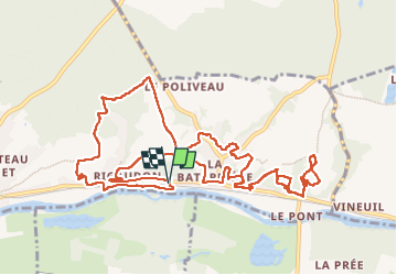

Length
14.3 km

Max alt
138 m

Uphill gradient
389 m
Km-Effort
19.5 km

Min alt
60 m

Downhill gradient
390 m
Boucle
Yes
Creation date :
2025-07-14 05:42:10.838
Updated on :
2025-07-14 10:50:55.222
2h51
Difficulty : Medium

FREE GPS app for hiking
 SityTrail
IGN / Geographical institutes
SityTrail Plus
The world is yours!
About
Trail Walking of 14.3 km to be discovered at Centre-Loire Valley, Loir-et-Cher, Montrichard Val de Cher. This trail is proposed by mimilolo.
Positioning
Country:
France
Region :
Centre-Loire Valley
Department/Province :
Loir-et-Cher
Municipality :
Montrichard Val de Cher
Location:
Unknown
Start:(Dec)
Start:(UTM)
365500 ; 5245115 (31T) N.
Comments